
I’m trying to have my labels for features only show when you are zoomed into that feature, sort of like the “Draw and label water features” in the HowDoI example. But I want the label to get bigger as I zoom into the feature, just like my feature does.
Ex:
//I create a feature, in this case an ellipse with 1000 ft. radius
PolygonShape polygoneShape = new PolygonShape();

polygoneShape = (new EllipseShape(new PointShape(0, 0), 1000, GeographyUnit.DecimalDegree, DistanceUnit.Feet)).ToPolygon();

Feature feature = new Feature(polygoneShape);
feature.ColumnValues.Add("styleName", "EmptyYellow2"); //custom style, just a yellow circle
feature.ColumnValues.Add("fontStyleName", "Title3Yellow"); //custom style, just yellow text
feature.ColumnValues.Add("label", spriteModel.Label);
My custom textstyle being used is constructed with the following properties set:
return new TextStyle
{
    Font = new GeoFont(FontName, FontSize, FontStyle | FontStyle2),
    TextSolidBrush = new GeoSolidBrush(FontColor),
    TextColumnName = TextColumnName,
    PointPlacement = PointPlacement.Center
};
Finally, the layer that the features will be in:
InMemoryFeatureLayer spritesLayer = new InMemoryFeatureLayer();
spritesLayer.Name = "Sprites Layer";
spritesLayer.ZoomLevelSet.ZoomLevel01.CustomStyles.Add(valueStyle); //valueStyle contains the styles for the polygon
spritesLayer.ZoomLevelSet.ZoomLevel01.CustomStyles.Add(fontValueStyle); //fontValueStyle contains the style for fonts
spritesLayer.ZoomLevelSet.ZoomLevel01.ApplyUntilZoomLevel = ApplyUntilZoomLevel.Level20;
spritesOverlay.Layers.Add(spritesLayer.Name, spritesLayer);
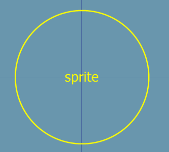
In the image below, you’ll see that the label is visible even when zoomed far out.
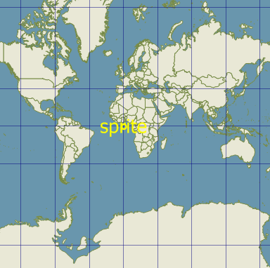
It stays the same size regardless of zoom level.
Instead, I want it to act like the feature, where the label gets bigger as you zoom in. How can I achieve this? Thanks!