Hi Ethan,
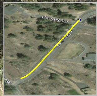
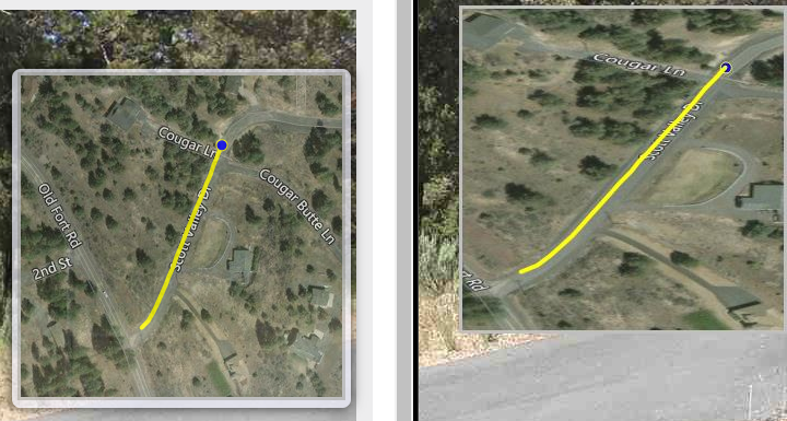
Sorry for the confusion. My first question is simply we want the circle to be on top of the line. In the image it shows the line on top of the point.
As for the second question, we would need to apply the projection to each of the items added to the canvas?
Here is the code
Dim objBitMap As Bitmap = New Bitmap(300, 300)
Dim objGeoCanvas As PlatformGeoCanvas = New PlatformGeoCanvas()
Dim colLayers As System.Collections.ObjectModel.Collection(Of SimpleCandidate) = New System.Collections.ObjectModel.Collection(Of SimpleCandidate)()
Dim colLineFeatures As System.Collections.ObjectModel.Collection(Of Feature) = New ObjectModel.Collection(Of Feature)()
Dim colPointFeatures As System.Collections.ObjectModel.Collection(Of Feature) = New ObjectModel.Collection(Of Feature)()
    Dim objLine As New LineShape
    Dim objVertex As Vertex
    Dim objImages As ArrayList = mobjViewer.RouteImageArray
    Dim objLatLng As List(Of KeyValuePair(Of String, String)) = mobjViewer.RouteLatLng
    Dim strLon As String = ""
    Dim strLat As String = ""
    Dim strItem As String = ""

    If objImages.Count > 0 Then
        Session.Item("ImagesPath") = ""
    End If

    Dim objProjectionJUR As Proj4Projection = New Proj4Projection()
    objProjectionJUR.InternalProjectionParametersString = Proj4Projection.GetDecimalDegreesParametersString
    objProjectionJUR.ExternalProjectionParametersString = Proj4Projection.GetGoogleMapParametersString
    objProjectionJUR.Open()

    For i As Integer = 0 To objImages.Count - 1
        If i > objLatLng.Count - 1 Then Exit For
        Dim strSplit As String() = Split(objLatLng(i).Value.ToString, ",")
        If IsNothing(strSplit) = False Then
            If strSplit.Count < 2 Then
            Else
                strLon = strSplit(0)
                strLat = strSplit(1)
            End If
        End If

        If Val(strLon) <> 0 And Val(strLat) <> 0 Then
            objVertex = objProjectionJUR.ConvertToExternalProjection(CDbl(strLon), CDbl(strLat))
            strLon = objVertex.X.ToString
            strLat = objVertex.Y.ToString
            objLine.Vertices.Add(objVertex)
            'ClientScript.RegisterHiddenField("mp" & objLatLng(i).Key.ToString, strLon & "," & strLat)
        End If
    Next

    'Creates the Point Shape
    Dim pointMap As New MapShape

    For Each objPair As KeyValuePair(Of String, String) In mobjViewer.RouteLatLng
        Dim objKey As String = objPair.Key
        Dim objValue As String = objPair.Value

        If objKey = mstrMPText Then
            Dim strLatLng As String() = objValue.Split(CChar(","))

            pointMap.Feature = objProjectionJUR.ConvertToExternalProjection(New Feature(CDbl(strLatLng(0).ToString()), CDbl(strLatLng(1).ToString())))
            pointMap.ZoomLevels.ZoomLevel01.DefaultPointStyle = PointStyles.CreateSimpleCircleStyle(New GeoColor(0, 0, 255), 10, New GeoColor(255, 255, 0), 1)
            pointMap.ZoomLevels.ZoomLevel01.ApplyUntilZoomLevel = ApplyUntilZoomLevel.Level20
            Exit For
        End If
    Next

    'Creates the Line Shape
    Dim linemap As New MapShape
    Dim ext As RectangleShape

    With linemap
        .Feature = New Feature(objLine)
        .ZoomLevels.ZoomLevel01.DefaultLineStyle = LineStyles.CreateSimpleLineStyle(GeoColor.StandardColors.Yellow, 4, True)
        .ZoomLevels.ZoomLevel01.ApplyUntilZoomLevel = ApplyUntilZoomLevel.Level20
        ext = .Feature.GetBoundingBox
    End With

    ext.ScaleUp(60)

    'Bing Map

    ' Please set your own information about those parameters below.
    Dim applicationID As String = "[Your Bing Key]"
    Dim cacheDirectory As String = HttpContext.Current.ApplicationInstance.Server.MapPath("~/App_Data/Bingmaps")

    If Directory.Exists(cacheDirectory) = False Then
        Directory.CreateDirectory(cacheDirectory)
    End If

    cacheDirectory = HttpContext.Current.ApplicationInstance.Server.MapPath("~/App_Data/Bingmaps/StreetPix")

    If Directory.Exists(cacheDirectory) = False Then
        Directory.CreateDirectory(cacheDirectory)
    End If

    'Begins Drawing the Image
    objGeoCanvas.BeginDrawing(objBitMap, ext, GeographyUnit.Meter)

    'Builds Bing Maps Layer
    Dim objLayer As New BingMapsLayer(applicationID, ThinkGeo.MapSuite.Layers.BingMapsMapType.Road, cacheDirectory)
    Dim strKey As String = ""
    objLayer.Logo = Nothing
    objLayer.Name = "Bing Maps"
    objLayer.DrawingExceptionMode = DrawingExceptionMode.DrawException
    objLayer.MapType = ThinkGeo.MapSuite.Layers.BingMapsMapType.AerialWithLabels

    strKey = objLayer.Name.Replace(" ", "") & "Layer"

    objLayer.TileCache = New FileBitmapTileCache(cacheDirectory)
    objLayer.Open()
    objLayer.Draw(objGeoCanvas, colLayers)
    objLayer.Close()

    'objGeoCanvas.DrawLine(linemap.Feature, linemap.ZoomLevels.ZoomLevel01.DefaultLineStyle.CenterPen, DrawingLevel.LevelFour)

    'Adds the Shapes
    'Dim objTempLayer As MapShapeLayer = New MapShapeLayer()
    'objTempLayer.MapShapes.Add("Line", linemap)
    'objTempLayer.Draw(objGeoCanvas, colLayers)
    colPointFeatures.Add(pointMap.Feature)
    pointMap.ZoomLevels.ZoomLevel01.DefaultPointStyle.Draw(colPointFeatures, objGeoCanvas, colLayers, colLayers)
    colLineFeatures.Add(linemap.Feature)
    linemap.ZoomLevels.ZoomLevel01.DefaultLineStyle.Draw(colLineFeatures, objGeoCanvas, colLayers, colLayers)

    'objTempLayer = New MapShapeLayer()
    'objTempLayer.MapShapes.Add("Point", pointMap)
    'objTempLayer.Draw(objGeoCanvas, colLayers)

    objGeoCanvas.EndDrawing()

    'Adds the border around the image
    Dim objBorder As Brush = New SolidBrush(Color.Silver)
    Dim objGraphics As Graphics = Graphics.FromImage(CType(objBitMap, Image))

    'objGraphics.FillRectangle(objBorder, 0, 0, 6, 6)
    objGraphics.DrawLine(New Pen(objBorder, 6), New Point(0, 0), New Point(0, 300))
    objGraphics.DrawLine(New Pen(objBorder, 6), New Point(0, 0), New Point(300, 0))
    objGraphics.DrawLine(New Pen(objBorder, 6), New Point(300, 0), New Point(300, 300))
    objGraphics.DrawLine(New Pen(objBorder, 6), New Point(0, 300), New Point(300, 300))
    Dim objPoint As Point = New Point(0, 0)
    objGraphics.DrawImage(objBitMap, objPoint)

    Return objBitMap
Thanks,
Neil