
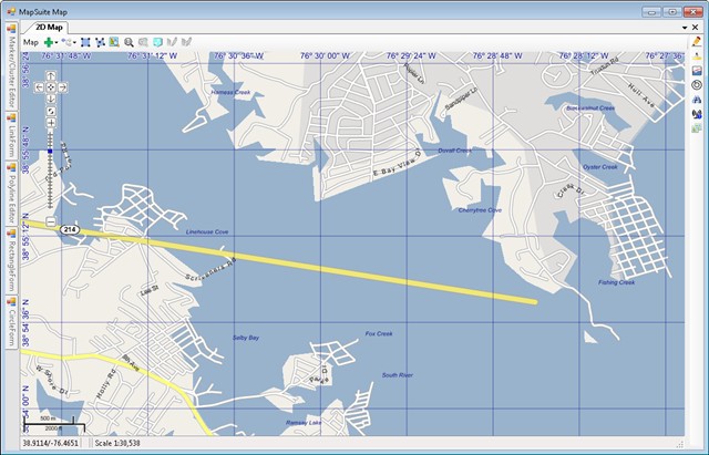
We use the World Map KIt 5.0 with the 2009 Street Data. We have noticed that the streets around Annapolis Maryland are shown as if they are over water. We have not seen this in other areas (at least not yet). Can anyone tell me if this is a bug or just bad shapefiles in the World Map Data Kit.?
WorldMapKit 5.0 floating streets
I have attached a screen shot of Annapolis Maryland
Hi Richard,
We checked the latest world map kit data and did find some lands missing in the before data. By viewing the latest datamaps.thinkgeo.com/web/
, we can get the below result: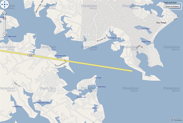
So, upgrading the world map kit data should can fix this issue. If you want to upgrade, please send email to support@thinkgeo.com.
BTW, while the latest data, we still can see the road 214 have extent to the sea which is not right. I think this is a new issue of the data and I have reported to our development team. If you are not urgent on the new issue, please waiting for the next release of world map kit. But if you are, also please sending email to support@thinkgeo.com to mention this new issue and then we will fix the new issue and assist you to finish the upgrade.
Regards,
Johnny
Johnny,
Thanks so much for the quick response. I appreciate that you take the time to research these issues so promptly.
I did some futher experimenting on this as well. What I discovered is that the "ocean" - blue water areas are defined in two shapefiles for the case of the Chesapeake Bay in the Annapolis area. One shapefile is the "Ocean.shp" located in the "World\Physical\ocean.shp" of the WorldMapKitData. This shape file contains the areas for the water shown in my screen capture above with the floating street. The second shapefile is the "USA\WAT\MD\MDwat.shp" in the WorldMapKitData. It shows water boundaries much closer to your screen capture and the streets are properly shown on the land. I am guessing that since the "ocean.shp" is worldwide that the precision is not provided by whatever mapping source is used for that shapefile. The "MDwat.shp" probably comes from some more accurate source for the local waterways.
As far as Rt 214 goes, it appears to just be error in the "USA\highwaynetwork2_2.shp". This is not an urgent issue for us. We were just trying to verify that these floating roads were not a result of some "coding issue" in our application such as the projection or something along that line. I had seem other discussion were the map had issues with things lining up and usually the answers dealt with defining the correct projection.
We will wait for the next relase of the world map kit.
Thank you for your assistance.
Richard
Hi Richard,
Thanks for share your research on this problem.
We keep trying to make everything looks better in each release version than before.
Regards,
Don