ThinkGeo.com    |     Documentation    |     Premium Support

Bing images fail to load

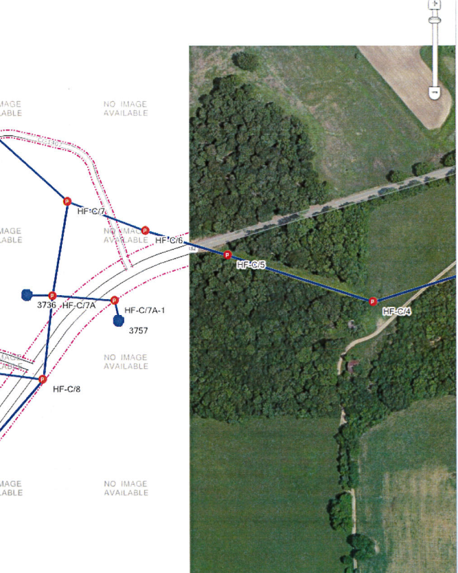
Recently our clients are seeing more and more times where the No Image Available on the Bing layer shows up. They have Bing Maps open in a browser and go to that same area and the image is available there. What needs to be done to make this layer more reliable?

var bngLayer = new BingMapsLayer(sBingKey, BingMapsMapType.Aerial);

Hi Jake,

We created one sample try to reproduce this issue but failed. There are some advice for you:

  1. Check the network is available, maybe it is caused by the network issue by some time.
  2. Please try to add SendingWebRequest event in bingLayer, you can get the request URL in this event. please check if it can be requested by WebBrowser.

If you can recreate this issue by one sample, please send that to us, we can help to check that. Our developer will dig more for this issue to see if there is any potential issue in our lib.

Thanks
Mark

When the tiles fail to load due to network connectivity we see a red tile with the Red x in it based on the show exception flag on your layers.

The image above shows half the tiles load with an image and half don’t. In most cases this occurs when zooming in close.

You should be able to go to there coordinates to recreate.

36.77823, -86.24620

Hi Jake,

Attached is our test sample, which is center at the point -86.24620, 36.77823.

When zoom into level 18, everything works well

And if we zoom deeper, all tiles shows no image available, that’s from the Bing server, which means for Aerial without image in this level.

So could you please test our sample to see whether we missed anything to reproduce that.
8637.zip (10.3 KB)

Any question please let us know.

Regards,

Don

The question our client’s want answered is what request is needed to get those images generated? I understand this is coming from Bing’s servers, but when going to Bing.com/maps we are able to see those tiles. Why are we not seeing those through your layer?

Hi Jake,

The data from the static library is different with Bing used in their online map, as 3rd part we can only visit the static map of Bing (https://msdn.microsoft.com/en-us/library/ff701724.aspx).

After research, we found for Aerial type of Bing, some special area (they should be out of urban area) in level 18 don’t have the valid tile image just like you found, so it render “No Image” tile, for example: http://ecn.t1.tiles.virtualearth.net/tiles/h032000323213230300.jpeg?g=5833&mkt=en-US&ZOOM=18

The solution should be:

  1. Limit the zoomlevel, you can remove level 19 and 20 from ZoomLevelSet, so user won’t visit the invalid area.

  2. Switch the background layer to Google Map or our WorldStreetsAndImageryOverlay.

Regards,

Don