Hi,
This issue is not a bug, it is caused by your incorrect projection text. You can build the correct projection text with following steps:
- Find the projection document in each zip file, it’s a htm file such as “Cape Lisburne SEC 51.htm”:
a. You can get the projection name for example “Lambert Conformal Conic” and the datum information for example “North American Datum of 1983”.
b. You can search the projection text with the information from http://spatialreference.org
For example:
b.1. Search the “Lambert Conformal Conic”:
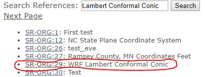
You can click “SR-ORG:29” and download .prj file, this file provides “Lambert Conformal Conic” projection text format.
b.2. Search the “North American Datum of 1983”
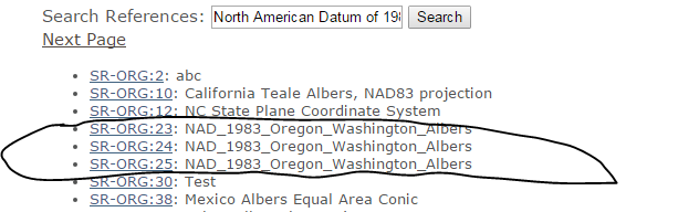
You can click “SR-ORG:25” (or 23, 24) and download .prj file, this file provides “1983” datum parameters.
- Get the correct projection text:
a. Some base projection information can be got from “Cape Lisburne SEC 51.htm”, such as:
Standard_Parallel: 65.33333333333333
Standard_Parallel: 70.66666666666667
Longitude_of_Central_Meridian: -164.75
Latitude_of_Projection_Origin: 70.3333333333
False_Easting: 0.000000
False_Northing: 0.000000
b. Open “SR-ORG:29” .prj file and replace these parameters as following:
1st Standard_Parallel: standard_parallel_1
2nd Standard_Parallel: standard_parallel_2
Longitude_of_Central_Meridian: central_meridian
Latitude_of_Projection_Origin: latitude_of_origin
False_Easting: false_easting
False_Northing: false_northing
c. Replace “GEOGCS”, “DATUM”, “SPHEROID” and “PRIMEM” parameters with the text from “SR-ORG:25” .prj file.
d. Get the final projection text : PROJCS[“WGC 84 / WRF Lambert”,GEOGCS[“GCS_North_American_1983”,DATUM[“D_North_American_1983”,SPHEROID[“GRS_1980”,6378137.0,298.257222101]],PRIMEM[“Greenwich”,0.0],UNIT[“Degree”,0.017453292519943295]],PROJECTION[“Lambert_Conformal_Conic”],PARAMETER[“central_meridian”, -164.75],PARAMETER[“latitude_of_origin”,70.3333333333],PARAMETER[“standard_parallel_1”,65.33333333333333],PARAMETER[“false_easting”,0.0],PARAMETER[“false_northing”,0.0],PARAMETER[“standard_parallel_2”,70.66666666666667],UNIT[“m”,1.0]]
-
Use “Proj4Projection” object to convert the correct project to WGS84 as following statements:
var prj = File.ReadAllText(@"…\AppData\new29.prj");
var projection = new Proj4Projection(Proj4Projection.ConvertPrjToProj4(prj),
Proj4Projection.GetWgs84ParametersString());
projection.Open();
-
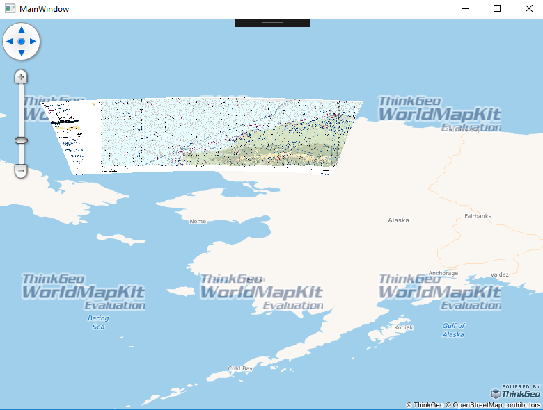
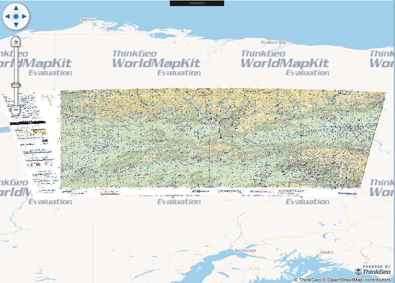
You can display the .tiff file to correct position, as following snapshot:
You can get the sample from https://ap.thinkgeo.com:5001/sharing/msrfHPYS8 , please have a try. If you have any questions, please let me know.
Thanks,