ThinkGeo.com    |     Documentation    |     Premium Support

Add WMS Overlay / Layer does not work

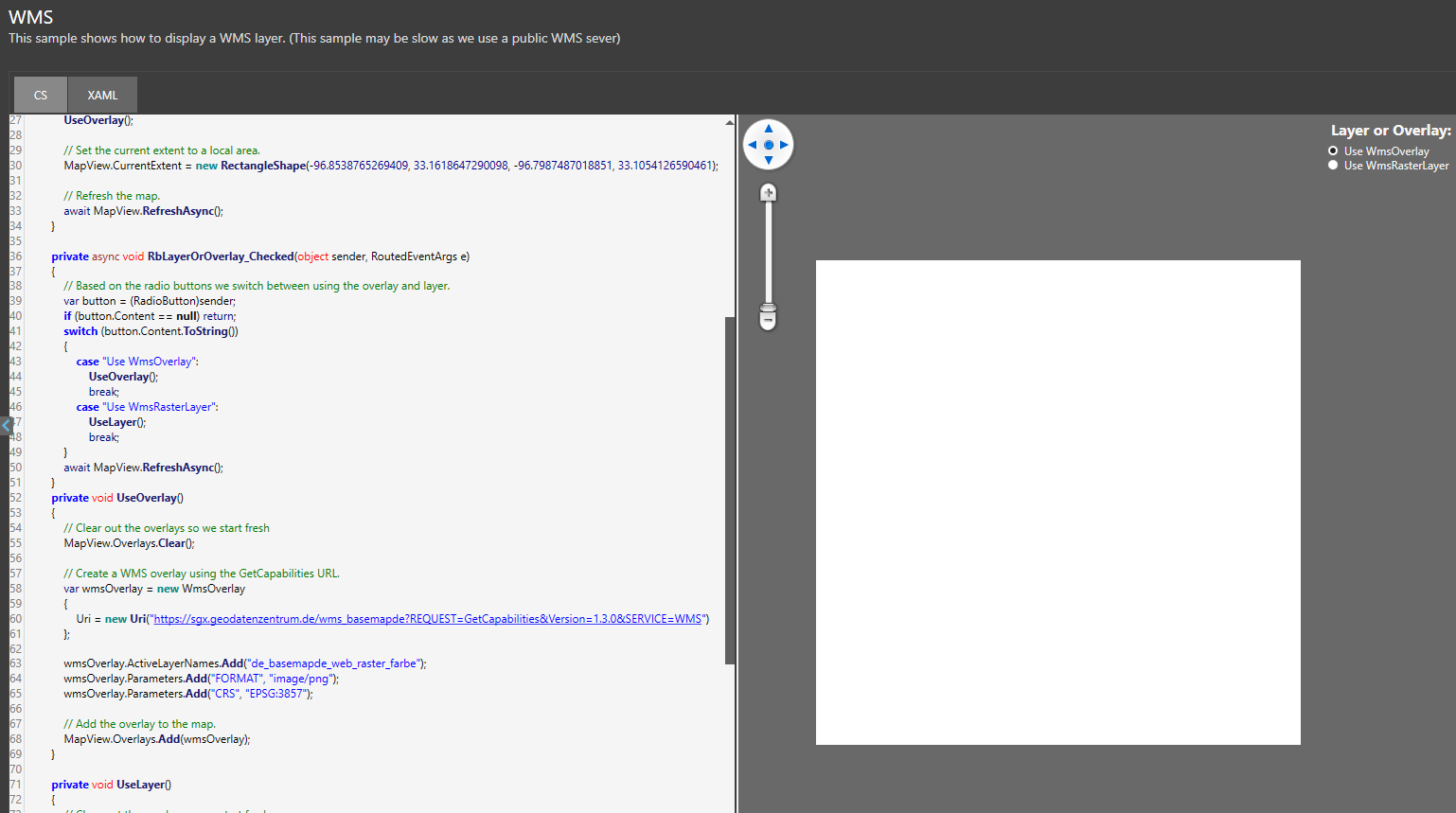
Hi, I am trying to add a WMS Overlay or Layer. However, neither gives me an expected result.

Within the HowDoI Application, I have adapted the Overlay to be like this:

        private void UseOverlay()
    {
        // Clear out the overlays so we start fresh
        MapView.Overlays.Clear();

        // Create a WMS overlay using the GetCapabilities URL.
        var wmsOverlay = new WmsOverlay
        {
            Uri = new Uri("https://sgx.geodatenzentrum.de/wms_basemapde?REQUEST=GetCapabilities&Version=1.3.0&SERVICE=WMS")
        };

        wmsOverlay.ActiveLayerNames.Add("de_basemapde_web_raster_farbe");
        wmsOverlay.Parameters.Add("FORMAT", "image/png");
        wmsOverlay.Parameters.Add("CRS", "EPSG:3857");

        // Add the overlay to the map.
        MapView.Overlays.Add(wmsOverlay);
    }

However, this returns me a white box:

https://sgx.geodatenzentrum.de/wms_basemapde?REQUEST=GetCapabilities&Version=1.3.0&SERVICE=WMS

Can you please help me how to get this to work? If you need any additional information please dont hesitate to ask, as I am new to working with WMS.

Thanks!

I have tried this with a different WMS Service and it still does not work.
I have read the Layers from the Server using this: wmsOverlay.GetServerLayers()
This works and returns me the two layers existing in this Service.
I then added one of the two layer names to my function as displayed below. This, however, only gives me a white square again, same result as above.

private void UseOverlay()
{
    // Clear out the overlays so we start fresh
    MapView.Overlays.Clear();

    // Create a WMS overlay using the GetCapabilities URL.
    var wmsOverlay = new WmsOverlay
    {
        Uri = new Uri("https://www.lfu.bayern.de/gdi/wms/boden/buek200by?")
    };

    wmsOverlay.ActiveLayerNames.Add("buek200");

    // Add the overlay to the map.
    MapView.Overlays.Add(wmsOverlay);
}

Inspecting the HttpMessage (like this) returns the following:

Debug Output:

https://www.lfu.bayern.de/gdi/wms/boden/buek200by?SERVICE=WMS&REQUEST=GetCapabilities

https://www.lfu.bayern.de/gdi/wms/boden/buek200by?REQUEST=GetMap&BBOX=-180,-270.6505430128364,180.6505430128364,90&WIDTH=512&HEIGHT=512&LAYERS=buek200&STYLES=default&FORMAT=image/png&CRS=EPSG:3857&VERSION=1.3.0&SERVICE=WMS

hi @Julian_Thoms,

It seems that the first WMS doesn’t work with EPSG:3857, we need to use CRS:84. You could try the following code.

I think there’s something wrong with the second WMS, either ThinkGeo or QGIS cannot work with it. Did you get it working with other GIS tools?

        MapView.MapUnit = GeographyUnit.DecimalDegree;

        // Create a WMS overlay using the GetCapabilities URL.
        var wmsOverlay = new WmsOverlay
        {
            Uri = new Uri("https://sgx.geodatenzentrum.de/wms_basemapde?REQUEST=GetCapabilities&Version=1.3.0&SERVICE=WMS")
        };

        wmsOverlay.ActiveLayerNames.Add("de_basemapde_web_raster_farbe");
        // use Property OutputFormat instead of Parameters.Add("FORMAT", "image/png");
        wmsOverlay.OutputFormat = "image/png";
        // use Property Crs instead of Parameters.Add("CRS", "xxxx");
        wmsOverlay.Crs = "CRS:84";

        // Add the overlay to the map.
        MapView.Overlays.Add(wmsOverlay);

        wmsOverlay.SendingHttpRequest += WmsOverlay_SendingHttpRequest;
        await wmsOverlay.OpenAsync();
        MapView.CurrentExtent = wmsOverlay.GetBoundingBox();

        await MapView.RefreshAsync();

Regards,
Leo

Hi Leo, thank you very much for your response.

We got it to work with ESRI ArcGIS Pro 3.4.2 like this:

Add Data -> Path -> Add the url as a path and “WMS OGC Web Service” as Service Type

I will try your suggestion and report back. However, we would like to offer a simple url dropin tool so that a custom WMS can be displayed. I thought that I can simply use the in the Capabilities mentioned EPSG / let the User pick one of those options, however this does not seem to work with ThinkGeo then? Or is that a WMS issue?

Hi Leo, I have tried your suggested code and got it to work - however, it is very warped, see:

Using ESRI ArcGIS Pro, adding it with the correct EPSG (25832) was no issue. However, when trying the same thing with ThinkGeo, it shows me the following Screen:

private async Task UseOverlay()
{
    Debug.WriteLine("Use overlay selected");
    // Clear out the overlays so we start fresh
    MapView.Overlays.Clear();

    // Create a WMS overlay using the GetCapabilities URL.
    var wmsOverlay = new WmsOverlay
    {
        Uri = new Uri("https://sgx.geodatenzentrum.de/wms_basemapde?REQUEST=GetCapabilities&Version=1.3.0&SERVICE=WMS")
    };

    wmsOverlay.ActiveLayerNames.Add("de_basemapde_web_raster_farbe");
    // use Property OutputFormat instead of Parameters.Add("FORMAT", "image/png");
    wmsOverlay.OutputFormat = "image/png";
    // use Property Crs instead of Parameters.Add("CRS", "xxxx");
    wmsOverlay.Crs = "EPSG:25832";

    // Add the overlay to the map.
    MapView.Overlays.Add(wmsOverlay);

    wmsOverlay.SendingHttpRequest += WmsOverlay_SendingHttpRequest;

    await wmsOverlay.OpenAsync();
    MapView.CurrentExtent = wmsOverlay.GetBoundingBox();

    await MapView.RefreshAsync();
}

Also, it does not seem to make an API call at all, as I do not get any output in the Debug output, neither from the SendingHttpRequest nor from the ThinkGeoDebugger which is set to “All”.

hi @Julian_Thoms,

I tried EPSG:25832 and it worked good. Here’s the sample WmsSample.zip (3.5 KB) , feel free to give it try. One thing to note is that the map size should not be too small, it appeared blank when the map size was 450 x 800, but it worked with a map size of 750 x 1200.

Regarding the EPSG options in capabilities, you could call wmsOverlay.GetServerCrsCollection() to get all the EPSG mentioned in capabilities xml.

Regards,
Leo

Hi Leo, thank you, we got this sample working! The issue with this particular one was that MapView.MapUnit was set to DecimalDegree which does not work with EPSG, only CRS. Quite obvious but it’s the first time I worked with WMS. Would it be possible to throw a warning if you have DecimalDegree set and a CRS Crs set? Currently, none is thrown, the API Call is simply not sent.

Thanks!

hi @Julian_Thoms,

MapUnit is for map, and map could have many different layers, and some layers might have reprojections, so it’s difficult to determine what the MapUnit is.

Regards,
Leo