ThinkGeo.com    |     Documentation    |     Premium Support

Black/Grey Rectangles Appearing on map

 See the attached image.  There are black rectangles appearing on the map when I load a WMS stream.  Is this because I'm using the unlicensed version?  I don't see these when I use the same WMS stream in other mapping applications.


Thanks


BlackBars.png (56 KB)

Josh, 
  
 I failed to recreate your issue with our WMS Server and I’m wondering if it has something to do with the WMS Server you’re visiting. Can you provide us the service URL if possible? You can send it to forumsupport@thinkgeo.com if you would like to. 
  
 We’re pretty sure that this problem is not caused by the unlicensed issue, nothing will be added to the map except for the unlicensed watermark when you’re evaluating our products. 
  
 We’ll continue to work on this as soon as we get the URL. Hope to get your feedback soon. 
  
 Thanks, 
  
 Ben

Here you go:  hsservices.datadoors.net/__streaminguid.6bb65af6-59e6-4738-9e4e-3eb807fe42dc/wms.ashx
  
 It’s the USA NationWide Prime 1m Layer

 Josh,


It seems something like logo/watermark from the server. Just by simply consuming the WMS from a browser and we can see this grey rectangle, please try the link below. 


hsservices.datadoors.net/__s...HEIGHT=256


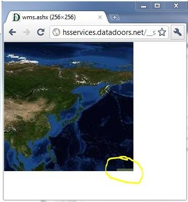
The WMSOverlay / WMSRasterLayer are getting the images by tiles so every tile is an independent query and it has that grey rectangle logo things. If we switch to SingleTile it will only have one on the bottom right but it might not be very responsive for loading a big image one time. 


 wmsOverlay.TileType = TileType.SingleTile;


I am not sure if the website provides something like premier users without any grey rectangles, that will be the best solution I think. 


Thanks,


Ben