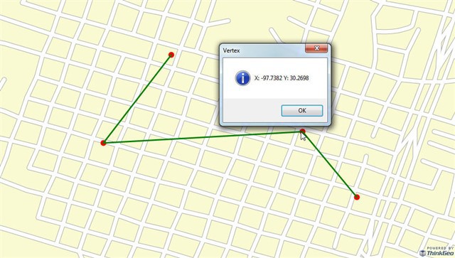
One way to do that is to use an InMemoryFeatureLayer with two features. Because, if you are just selecting a vertex and displaying, you don't need an EditInterectiveOverlay. Of the two features, one for the line itself and another one for the vertex. In the code below, I use the MapClick event to select a vertex and display its X and Y values in a message box. I hope this will help.
 private void Post7115()
        {

            winformsMap1.MapClick += new EventHandler<MapClickWinformsMapEventArgs>(winformsMap1_MapClick);

            winformsMap1.MapUnit = GeographyUnit.DecimalDegree;
            winformsMap1.CurrentExtent = new RectangleShape(-97.7487, 30.274, -97.7343, 30.2658);
            winformsMap1.BackgroundOverlay.BackgroundBrush = new GeoSolidBrush(GeoColor.StandardColors.LightGoldenrodYellow);

            ShapeFileFeatureLayer streetLayer = new ShapeFileFeatureLayer(@"..\..\Data\austinstreets.shp");
            streetLayer.ZoomLevelSet.ZoomLevel01.DefaultLineStyle = LineStyles.LocalRoad2;
            streetLayer.ZoomLevelSet.ZoomLevel01.ApplyUntilZoomLevel = ApplyUntilZoomLevel.Level20;

            LayerOverlay staticOverlay = new LayerOverlay();
            staticOverlay.Layers.Add("StreetLayer", streetLayer);
            winformsMap1.Overlays.Add(staticOverlay);

            LineShape lineShape = new LineShape();
            lineShape.Vertices.Add(new Vertex(-97.744, 30.2732));
            lineShape.Vertices.Add(new Vertex(-97.747, 30.2693));
            lineShape.Vertices.Add(new Vertex(-97.7382, 30.2698));
            lineShape.Vertices.Add(new Vertex(-97.7358,30.2669));

            MultipointShape multipointShape = new MultipointShape();
            foreach (Vertex vertex in lineShape.Vertices)
            {
                multipointShape.Points.Add(new PointShape(vertex));
            }

            InMemoryFeatureLayer inMemoryFeatureLayer = new InMemoryFeatureLayer();
            inMemoryFeatureLayer.ZoomLevelSet.ZoomLevel01.DefaultPointStyle = PointStyles.CreateSimpleCircleStyle(GeoColor.StandardColors.Red, 12);
            inMemoryFeatureLayer.ZoomLevelSet.ZoomLevel01.DefaultLineStyle = LineStyles.CreateSimpleLineStyle(GeoColor.StandardColors.Green, 3, true);
            inMemoryFeatureLayer.ZoomLevelSet.ZoomLevel01.ApplyUntilZoomLevel = ApplyUntilZoomLevel.Level20;

            inMemoryFeatureLayer.Open();
            inMemoryFeatureLayer.EditTools.BeginTransaction();
            inMemoryFeatureLayer.EditTools.Add(new Feature(multipointShape));
            inMemoryFeatureLayer.EditTools.Add(new Feature(lineShape));
            inMemoryFeatureLayer.EditTools.CommitTransaction();
            inMemoryFeatureLayer.Close();

            LayerOverlay lineOverlay = new LayerOverlay();
            lineOverlay.Layers.Add("Line", inMemoryFeatureLayer);


            winformsMap1.Overlays.Add(lineOverlay);

            winformsMap1.Refresh(lineOverlay);
        }

        void winformsMap1_MapClick(object sender, MapClickWinformsMapEventArgs e)
        {
            FeatureLayer Layer = winformsMap1.FindFeatureLayer("Line");

            Layer.Open();
            Collection<Feature> selectedFeatures = Layer.QueryTools.GetFeaturesNearestTo(e.WorldLocation, GeographyUnit.DecimalDegree, 2,ReturningColumnsType.NoColumns);  // GetFeaturesContaining(e.WorldLocation, new string[1] { "CNTRY_NAME" });
            Layer.Close();

            if (selectedFeatures.Count > 0)
            {
                foreach (Feature feature in selectedFeatures)
                {
                    if (feature.GetWellKnownType().ToString() == "Multipoint")
                    {
                        MultipointShape multipointShape = (MultipointShape)feature.GetShape();
                        PointShape pointShape = multipointShape.GetClosestPointTo(e.WorldLocation, GeographyUnit.DecimalDegree);
                        MessageBox.Show("X: " + Math.Round(pointShape.X,4) + " Y: " + Math.Round(pointShape.Y,4), "Vertex", MessageBoxButtons.OK, MessageBoxIcon.Information, MessageBoxDefaultButton.Button1, (MessageBoxOptions)0);
                    }
                }
            }
        }

