ThinkGeo.com    |     Documentation    |     Premium Support

Labels & Point Symbols being Cut Off at Tile Edges

Hi,


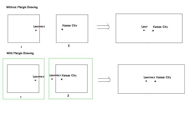
I'm using the latest version of the Map Suite Web Edition Beta and I've been noticing a problem where my point symbol icons and labels get cut off if they are near the edge of a tile.  How do I keep this from happening?


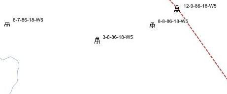
Below are some screen shots, look at the oil well point symbol on the left of the first screen shot and you will notice the top half is missing.


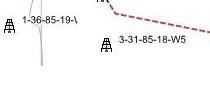
On the screen shot below you can see where the label for the left oil well is cut off at the end and only part of the W5 is being displayed.


Any help you can provide would be appreciated.


Thanks!


 Clint,


 This problem can be solved by setting the DrawingMarginPercentage property of a layer.
 
wellsLayer.DrawingMarginPercentage = 50;
 
As you see, the map is drawn by tile. So there is a possibility that a text is drawing at the edge and part of the text is outside the tile, which will be gone after we clip it. To solve this problem, we can draw larger area than the tile and in this way, we can show the text properly.
 
Here is a sample how it works. Image 1 and image 2 are 2 tiles next to each other. If there is no margin drawing, the first tile will only get the “Lawr” and the 2nd tile does not have anything related to Lawrence, so the final result you can see is the text being cut. While if we enable the margin drawing, the map will draw a larger tile first (Green Tile) and then cut it to the standard one, so for this case, tile 2 will get “ence” for Lawrence and when merged with Tile 1, the text is complete.


You can also see the larger marginePercentage you set, the fewer possible a text will be cut, and the less performance it will have.
 
I hope it make sense. And let us know for more queries.
 
Ben.


Supposing that the problem is not labels, but rather that we are drawing a collection of PointStyle objects offset a little bit from the feature, far enough to be on the next tile over.   In this case, we are missing seeing the PointStyle.Triangle, PointStyle.Circle, etc. that we are drawing on certain zoom levels because they fall onto the next tile.  What do we set at the layer level to get the feature to be drawn on the next tile too?

Hi Hal, 
  
 Sorry maybe I haven’t understanding your scenario, could you please give more information about that, for example an image about it? 
  
 This problem should only works for label, because label is a special level in map, shapes won’t be cut off by tiles. 
  
 Regards, 
  
 Don