Thanks,
The GIS Editor not get update for a while. You can try with the sample
Here is the code to load the data.
private void MapView_Loaded(object sender, RoutedEventArgs e)
    {
        // It is important to set the map unit first to either feet, meters or decimal degrees.
        mapView.MapUnit = GeographyUnit.Meter;

        // Create the background world maps using vector tiles requested from the ThinkGeo Cloud Service and add it to the map.
        ThinkGeoCloudVectorMapsOverlay thinkGeoCloudVectorMapsOverlay = new ThinkGeoCloudVectorMapsOverlay("itZGOI8oafZwmtxP-XGiMvfWJPPc-dX35DmESmLlQIU~", "bcaCzPpmOG6le2pUz5EAaEKYI-KSMny_WxEAe7gMNQgGeN9sqL12OA~~", ThinkGeoCloudVectorMapsMapType.Light);
        mapView.Overlays.Add(thinkGeoCloudVectorMapsOverlay);

        // Create a new overlay that will hold our new layer and add it to the map.
        LayerOverlay fileGeoDatabaseOverlay = new LayerOverlay();
        mapView.Overlays.Add("overlay", fileGeoDatabaseOverlay);

        // Create the new layer and set the projection as the data is in srid 2276 and our background is srid 3857 (spherical mercator).
        FileGeoDatabaseFeatureLayer fileGeoDatabaseFeatureLayer = new FileGeoDatabaseFeatureLayer(@"C:\Users\FrankFu\Downloads\1\lion\lion.gdb");
        fileGeoDatabaseFeatureLayer.FeatureSource.ProjectionConverter = new ProjectionConverter(2263, 3857);
        fileGeoDatabaseFeatureLayer.ActiveLayer = "node";  // lion

        // Add the layer to the overlay we created earlier.
        fileGeoDatabaseOverlay.Layers.Add("Zoning", fileGeoDatabaseFeatureLayer);

        // Create an Area style on zoom level 1 and then apply it to all zoom levels up to 20.
        fileGeoDatabaseFeatureLayer.ZoomLevelSet.ZoomLevel01.DefaultAreaStyle = new AreaStyle(GeoPens.Black, new GeoSolidBrush(new GeoColor(50, GeoColors.Blue)));
        fileGeoDatabaseFeatureLayer.ZoomLevelSet.ZoomLevel01.DefaultPointStyle = new PointStyle(PointSymbolType.Circle, 2 , new GeoSolidBrush(GeoColors.Red));

        fileGeoDatabaseFeatureLayer.ZoomLevelSet.ZoomLevel01.ApplyUntilZoomLevel = ApplyUntilZoomLevel.Level20;

        // Open the layer and set the map view current extent to the bounding box of the layer.
        fileGeoDatabaseFeatureLayer.Open();
        mapView.CurrentExtent = fileGeoDatabaseFeatureLayer.GetBoundingBox();

        //Refresh the map.
        mapView.Refresh();
    }
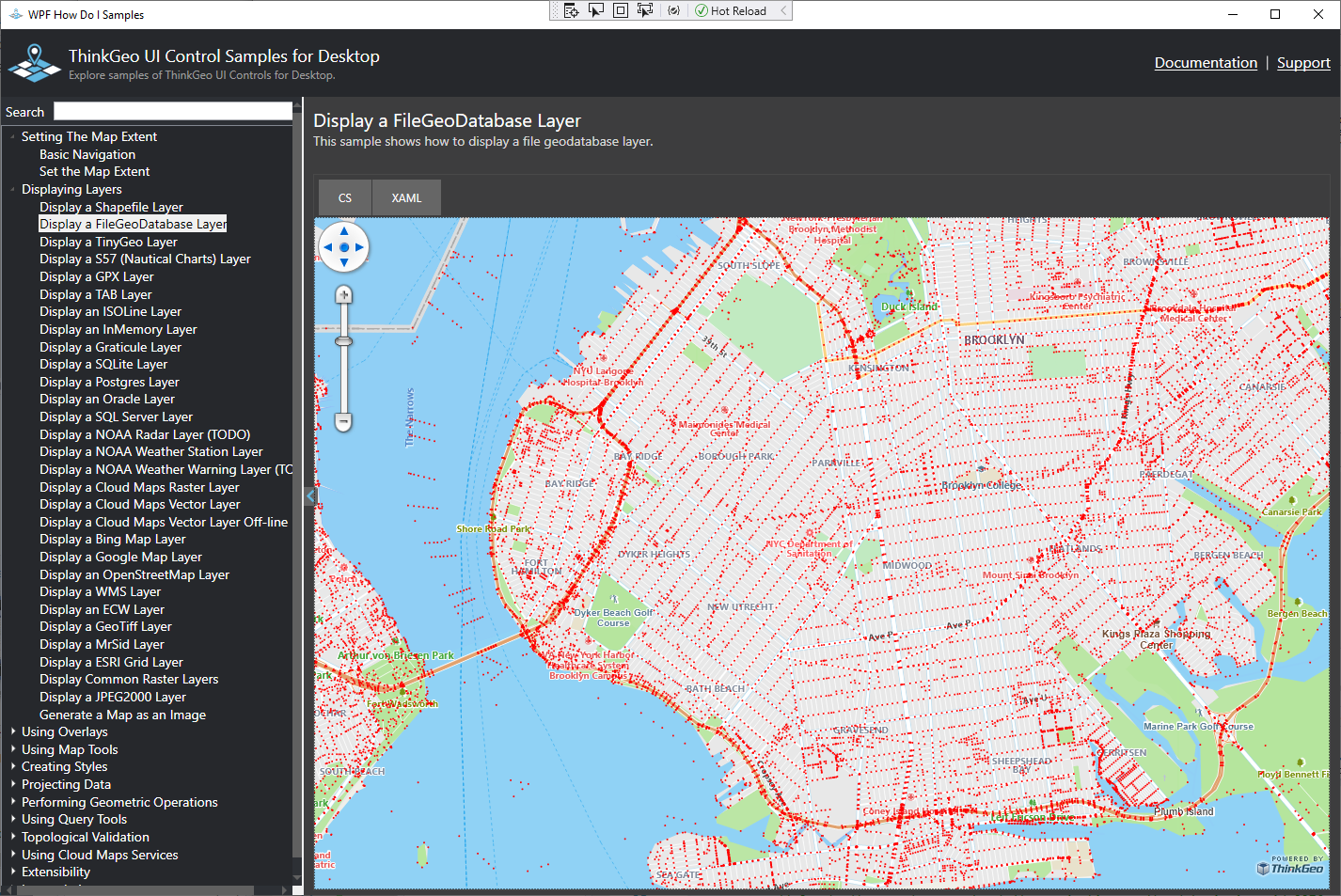
You will get something like this one.
If you display all items at a very high level. It may slow.
You could use this smaple
https://gitlab.com/thinkgeo/public/thinkgeo-desktop-maps/-/blob/master/samples/wpf/HowDoISample/Samples/CreatingStyles/CreateClusterPointStyleSample.xaml.cs to cluster the points.
Thanks
Frank