Hi
I’ve attempted to use ProjectionConverter for projecting points from WGS84 to the British National Grid. It functions correctly with the EPSG code, but not when utilizing the Proj string.
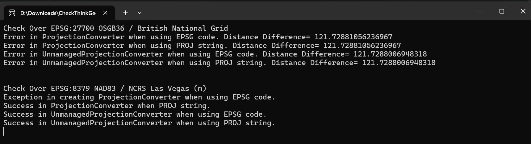
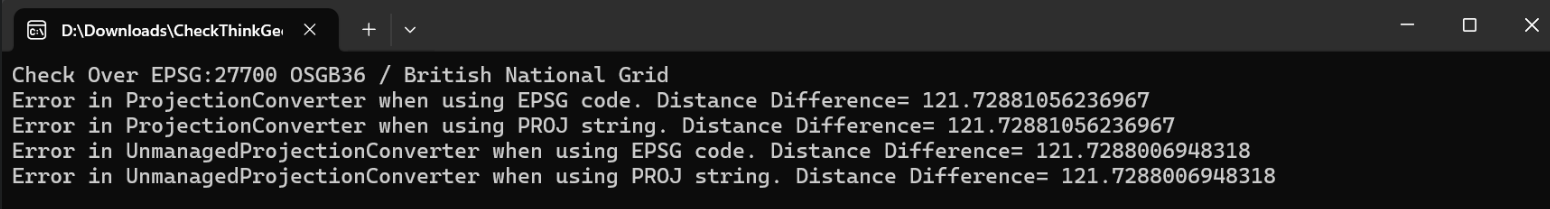
Check Over EPSG:27700 OSGB36 / British National Grid
Success in ProjectionConverter when using EPSG code.
Error in ProjectionConverter when using PROJ string. Distance Difference= 121.72881056236967
Success in UnmanagedProjectionConverter when using EPSG code.
Error in UnmanagedProjectionConverter when using PROJ string. Distance Difference= 121.7288105637554
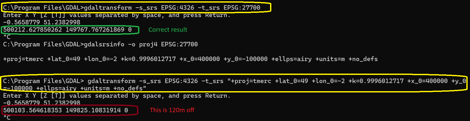
The discrepancy when using Proj4 is approximately 120 meters compared to the results from EPSG.IO, whereas using the Code shows no difference.
However, the main issue is our plan to support the projection for the latest EPSG code, such as EPSG:8379 NAD83 / NCRS Las Vegas (m). We are aware that this is not supported by ThinkGeo.ProjectionConverter, so we opted to obtain the Proj string from GDAL and then use the ProjectionConverter by passing the Proj string instead of the code. Consequently, while passing the code resulted in an exception, using the Proj string led to a significant discrepancy when comparing the transformation of the Point from WGS84 to EPSG:8379 with EPSG.IO.
Based on the information we found in the forum, we chose to use the UnmanagedProjectionConverter, which utilizes GDAL in the background. However, we encountered the same issue. Upon examining the GDAL dependency, I discovered that we were using an older version that does not support 8379.
Exception in creating ProjectionConverter when using EPSG code.
Error in ProjectionConverter when using PROJ string. Distance Difference= 416967.8247974478
ERROR 6: EPSG PCS/GCS code 8379 not found in EPSG support files.  Is this a valid EPSG coordinate system?
Exception in creating UnmanagedProjectionConverter when using EPSG code.
Error in UnmanagedProjectionConverter when using PROJ string. Distance Difference= 416967.8247974526
Could you please advise us on how to support the latest projection in our product?
P.S: The sample project is attached to this topic for further investigation.
CheckThinkGeoProjection.zip (5.0 KB)
internal abstract class CheckOverProjection
{
    //The PROJ strings is come from GDAL latest version
    private const string PROJ_4326 = "+proj=longlat +datum=WGS84 +no_defs";


    public void Check()
    {
        ProjectionConverterWithCode();
        ProjectionConverterWithProjString();
        UnmanagedProjectionConverterWithCode();
        UnmanagedProjectionConverterWithProjString();
    }

    protected abstract string TargetPROJ { get; }
    protected abstract int TargetEPSGCode { get; }
    protected abstract PointShape PointInWGS { get; }
    protected abstract PointShape ExpectedProjectedPoint { get; }

    private void ProjectionConverterWithCode()
    {
        try
        {
            var projectionConverter = new ProjectionConverter(4326, TargetEPSGCode);
            projectionConverter.Open();
            var projectedPoint = projectionConverter.ConvertToExternalProjection(PointInWGS);
            var distanceDiff = ExpectedProjectedPoint.GetDistanceTo(projectedPoint, GeographyUnit.Meter, DistanceUnit.Meter);
            if (distanceDiff > 2)
            {
                Console.WriteLine($"Error in ProjectionConverter when using EPSG code. Distance Difference= {distanceDiff}");
            }
            else
            {
                Console.WriteLine("Success in ProjectionConverter when using EPSG code.");
            }

        }
        catch (Exception)
        {
            Console.WriteLine($"Exception in creating ProjectionConverter when using EPSG code.");
        }

    }

    private void ProjectionConverterWithProjString()
    {
        try
        {
            var projectionConverter = new ProjectionConverter(PROJ_4326, TargetPROJ);
            projectionConverter.Open();
            var projectedPoint = projectionConverter.ConvertToExternalProjection(PointInWGS);
            var distanceDiff = ExpectedProjectedPoint.GetDistanceTo(projectedPoint, GeographyUnit.Meter, DistanceUnit.Meter);
            if (distanceDiff > 2)
            {
                Console.WriteLine($"Error in ProjectionConverter when using PROJ string. Distance Difference= {distanceDiff}");
            }
            else
            {
                Console.WriteLine("Success in ProjectionConverter when PROJ string.");
            }
        }
        catch (Exception)
        {
            Console.WriteLine($"Exception in creating ProjectionConverter when using PROJ string.");
        }
    }

    private void UnmanagedProjectionConverterWithCode()
    {
        try
        {
            var projectionConverter = new UnmanagedProjectionConverter(4326, TargetEPSGCode);
            projectionConverter.Open();
            var projectedPoint = projectionConverter.ConvertToExternalProjection(PointInWGS);
            var distanceDiff = ExpectedProjectedPoint.GetDistanceTo(projectedPoint, GeographyUnit.Meter, DistanceUnit.Meter);
            if (distanceDiff > 2)
            {
                Console.WriteLine($"Error in UnmanagedProjectionConverter when using EPSG code. Distance Difference= {distanceDiff}");
            }
            else
            {
                Console.WriteLine("Success in UnmanagedProjectionConverter when using EPSG code.");
            }
        }
        catch (Exception)
        {
            Console.WriteLine($"Exception in creating UnmanagedProjectionConverter when using EPSG code.");
        }
    }

    private void UnmanagedProjectionConverterWithProjString()
    {
        try
        {
            var projectionConverter = new UnmanagedProjectionConverter(PROJ_4326, TargetPROJ);
            projectionConverter.Open();
            var projectedPoint = projectionConverter.ConvertToExternalProjection(PointInWGS);
            var distanceDiff = ExpectedProjectedPoint.GetDistanceTo(projectedPoint, GeographyUnit.Meter, DistanceUnit.Meter);
            if (distanceDiff > 2)
            {
                Console.WriteLine($"Error in UnmanagedProjectionConverter when using PROJ string. Distance Difference= {distanceDiff}");
            }
            else
            {
                Console.WriteLine("Success in UnmanagedProjectionConverter when using PROJ string.");
            }
        }
        catch (Exception)
        {
            Console.WriteLine($"Exception in creating UnmanagedProjectionConverter when using PROJ string.");
        }
    }
}
Check over 27700 National Grid source code:
internal class CheckOverBNG : CheckOverProjection
{
    protected override string TargetPROJ => "+proj=tmerc +lat_0=49 +lon_0=-2 +k=0.9996012717 +x_0=400000 +y_0=-100000 +ellps=airy +units=m +no_defs";

    protected override int TargetEPSGCode => 27700;

    //Point in United Kingdom - Guildford (GLive)
    protected override PointShape PointInWGS => new PointShape(-0.5658779, 51.2382998);

    //Get it from EPSG.io
    protected override PointShape ExpectedProjectedPoint => new PointShape(500211.15180555126, 149768.161870003);
}
Check over LasVegas:
internal class CheckOverLasVegas : CheckOverProjection
{
    protected override string TargetPROJ => "+proj=tmerc +lat_0=36.25 +lon_0=-114.966666666667 +k=1.0001 +x_0=100000 +y_0=200000 +datum=NAD83 +units=m +no_defs";

    protected override int TargetEPSGCode => 8379;

    //Point in LasVegas - Best-Buy
    protected override PointShape PointInWGS => new PointShape(-115.1356839, 36.1197602);

    //Get it from EPSG.io
    protected override PointShape ExpectedProjectedPoint => new PointShape(500211.15180555126, 149768.161870003);
}