Hi,
What is the scale of the map? Centimeters?
I need to convert the scale and display in meters. Is it a simple conversion or do I need some additional adjustment?
Thank you

Hi,
What is the scale of the map? Centimeters?
I need to convert the scale and display in meters. Is it a simple conversion or do I need some additional adjustment?
Thank you
Hi Danilo,
The scale is a ratio of distance, it don’t have unit. Please view this topic for more detail: https://en.wikipedia.org/wiki/Scale_(map)
So I am not sure what you want to shows on map, if you want to show currently scale, please try our ScaleBar or ScaleLine.
Wish that’s helpful.
Regards,
Ethan
Hi, Ethan, thanks for the reply.
I’ll explain what I need.
I’m in a migration project from WPF to Xamarin (Android) and the project map displays scale information in centimeters, meters or kilometers.
For example, if the scale is 1: 100 000, the map displays only 1 KM.
In the old project the calculation for this display is not a simple calculation of unit conversion (centimeter to meters, for example), but uses a 0.887 constant for this (I do not know why). So my question is this:
To get this kind of display to scale, do I need to worry about some extra parameter or is it just a simple conversion? Is there anything that can influence this?
Thank you
Hi Danilo,
In fact we don’t have a 0.887 constant, so I don’t know where it is used.
I think you can don’t worry about the unit change, if you choose correct unitFamily, the unit will automatic get changed follow zoom in and zoom out, it make the scale line won’t be too long or too short.
But if you want to custom the unit please view our sample here, which should be helpful:
http://wiki.thinkgeo.com/wiki/source_code_webeditionsample_customscalebar_cs_100810.zip
Regards,
Ethan
Got it.
Thank you, Ethan.
Ethan,
Our idea is to do something similar to Google Maps, see below:
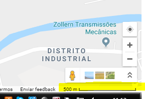
The map is with “MapUnit” = “GeographyUnit.Feet”.
We need to convert the scale to display this way. Any tips?
Thank you
Hi,
If you zoom out in GoogleMap you will found the unit keep changed also.
For example: 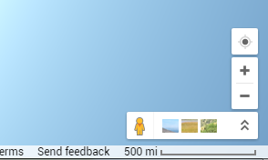
I think our map have a scale line which looks like it, you can try it.
If that’s not works, you need to build custom control for it, that’s not easy.
Regards,
Ethan
Got it.
Scale is a distance map ratio of the actual size, right?
The “CurrentScale” property of the map indicates that each unit on the map corresponds to this value (CurrentScale) at the actual size, correct?
Hi Danilo,
Q: Scale is a distance map ratio of the actual size, right?
A: That’s right
Q: The “CurrentScale” property of the map indicates that each unit on the map corresponds to this value (CurrentScale) at the actual size, correct?
A: That’s right, in our map we have a concept named ZoomLevel, each zoomlevel have its scale value, it’s predetermined and map will calculate the valid render area by it and the map unit. As below is a simple calculate sample about it:
Scale = InchPerMeter * DPI * resolution;
Wish that’s helpful.
Regards,
Ethan
Thank you, Ethan.
Let’s look at the best way to implement it.
Hi Danilo,
Wish our reply is helpful.
Regards,
Ethan