Hello everyone,
I'm trying to load Map Info Tab File that contains Text and Symbol objects like below:

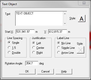
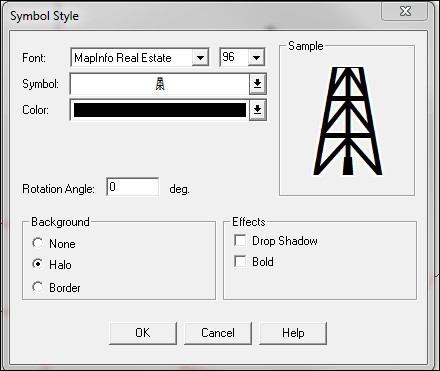
How can I load/read this Text and Symbol Objects that have been created using MapInfo Professional?
Thanks in advance.

Hello everyone,
I'm trying to load Map Info Tab File that contains Text and Symbol objects like below:
How can I load/read this Text and Symbol Objects that have been created using MapInfo Professional?
Thanks in advance.
Hi Anggi,
Thanks for your post, you can set TextStyle to show the text in each feature, please check the below code snippet:
TabFeatureLayer tabFeatureLayer = new TabFeatureLayer(@"Test.TAB");
                tabFeatureLayer.ZoomLevelSet.ZoomLevel01.ApplyUntilZoomLevel = ApplyUntilZoomLevel.Level20;
            tabFeatureLayer.ZoomLevelSet.ZoomLevel01.DefaultTextStyle = TextStyles.CreateSimpleTextStyle("PLACENAME", "Arial", 12, DrawingFontStyles.Regular, GeoColor.StandardColors.Black, GeoColor.FromArgb(100, GeoColor.SimpleColors.Green), 2, 0, -8);
For Symbol object, sorry but to limit the Tab file size our products cannot support reading information of Symbol from Tab file. You can use the Marker to replace the Symbol to achieve your require, but you need read the Symbol information with your own logic. Also you can raise a professional service for us to check this feature.
Sorry for the inconvenience.
Regards,
Gary
Hello Gary, thank you for your reply.
I already know about the TextStyle, and it can only show text from column value, right? But I want to show text object created from MapInfo Professional, like in the screenshot in my first post I just updated.
Thanks. :)
Hello Anggi,
I believe the text which MapInfo created is dat file, and you need open that file and parse it, then use our text and pass in any useful information you need.
Feel free to let me know if I misunderstanding it.
Regards,
Gary
how do I parse the .DAT file?
I try to open the .DAT file using text editor like notepad++, but all I can see is only binary data and some column name, not the "TEXT OBJECT's Text" value.
Hello Gary,
update: I can see the text value in the .MAP file, but how do we parse this .MAP file and show the Text in it?
Thank you very much for your help.
Hello Anggi,
My apologize, I’m confused with .Map and .Dat file here.
About the .Dat file, you can use our GisEditor to check it, but inside it, it only stores the column value.
And the text which MapInfo created store inside the .Map file, but for now we can only get the coordinate information but not the definition object like resource, symbol, line and text.
So for now we can’t show the ‘TEXT OBJECT’s Text’, sorry for the inconvenience.
Regards,
Gary
Hello Gary,
Thank you for your explanation.
Any future plan / roadmap for ThinkGeo to fully support read/write MapInfo .TAB including .MAP file?
Because we currently have a lot of MapInfo file from our client that have the text and symbol object. We really need to display this MapInfo file correctly.
Hello Anggi,
We are working on MapSuite 7.0 public release now, so this is not on the plan list yet.
You can vote this enhancement to helpdesk.thinkgeo.com/EnhancementTracker. This captures the enhancement request and provides visibility to the customer letting them know that the enhancement is on a list somewhere and that popularity of the enhancement helps set the priority of when the enhancement would be added to the product. This option doesn’t carry any cost for you.
Or if you need this function immediately, your account rep can contact you for a professional services.
Regards,
Gary