ThinkGeo.com    |     Documentation    |     Premium Support

Trial version - Visual Studio 2019 NuGet

Hello,
I would like to test your components for use in my new WinForms application.
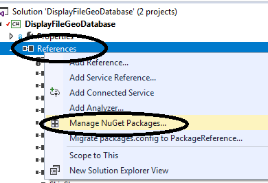
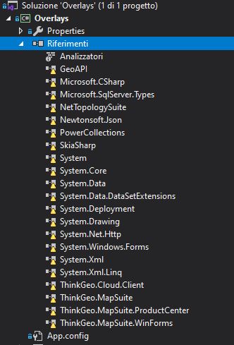
To begin with, I downloaded some of your GitHub sample projects, but can’t build them with VS2019 (eg. “Overlay” sample).
All components in the VS2019 “References” list have a yellow triangle.
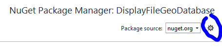
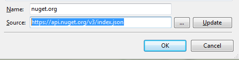
In VS2019’s “NuGet” configuration I added your package source “https://www.nuget.org/packages?q=ThinkGeo”, but it doesn’t work.

Cattura


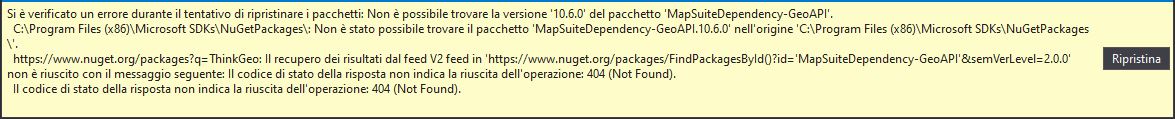
(excuse me for italian language Images )

Can you help me?

Another question…
After I have added the layers (eg. shapefiles) on the map and I have customized the style of each layer, how can I save the map/view/project (eg. “MapSuiteGisEditor” tgproj files) to be able to reuse it?

Thank you in advance
Best Regards

Hi Matteo,

Thanks to let us know your question.

After you download a sample from GitHub, it don’t contains the packages because the size is too big, it only contains a package list file in project.

So you should want to restore the packages:

  1. Right click on the “References” and Click “Manage NuGet Packages”.

image

  1. Click “Restore” button, generally directly build the project it will automatic download the packages

  2. If it still have problem, you can try:
    a. Manual add the packages from local folder into reference, you can find a folder named “packages” under your project folder

b. In NuGet plugin to remove the packages and add them back again
image

  1. It looks your are using NuGet v2 source, you should want to replace it to NuGet v3 source https://api.nuget.org/v3/index.json
    image
    image

About the second question:
The MapSuiteGisEditor is an utility, it’s different with your project.

If you want to reuse your logic, you can put your code into a class, then copy the class can reuse it in other projects.

If you want to share your logic like a library, you can build a dll, the other guys can reference it in their project.

I hope that’s helpful. Any question please let us know.

Regards,

Ethan

Hello Ethan,
… and thanks for the reply.
I will follow your Nuget advices.

About “summary/view” map (eg. tgproj files)…
With our application, we want to provide our customers with an already themed map consisting of raster and/or vector layers.
So, when the customer opens the map in our application, he finds an already configured map (layer order, layer style, layer scale, labels, etc.).
Since your component does not currently have a ready-made Legend control, to organize the layers and customize their style, I thought of using “MapSuiteGisEditor” to generate the “summary/view” map file and then open it in my application.
If your map control is unable to read the tgproj files saved with the “MapSuiteGisEditor” utility, I have to implement in my application a Legend control to load, organize and customize the style of the map layers. Also, I should implement the saving and loading of a “summary / view” map file that I have to invent (tgproj files are zip files).

All this would take too developing time…

Thank you
Bast Regards

Hi Matteo,

The GisEditor is based on map control, but the project format is a feature of GisEditor, map control don’t contains it.

The GisEditor is open source now, so I think you can reference the code about how to implement it. I think it should implemented based on searialize, we have a namespace ThinkGeo.MapSuite.Serialize contains some class about it.

I hope that’s helpful.

Regards,

Ethan