ThinkGeo Team,
An exception occurs from GetAllFeatures.
Same code & data runs under V12.1.0 without issue.
Thanks,
Dennis
Code leading to the exception:
GetAllFeatures(ReturningColumnsType.AllColumns, 0, 1);
and
cAllFeatures = oDatabaseTableItem.FeatureSource.GetAllFeatures(ReturningColumnsType.AllColumns, 0, 9000);
2025-03-13 15:01:18,723 ERROR OriStarFileDatabaseViewer - OriStarFileDatabaseViewer->GeneralMethods.PopulateDatabaseCollectionGdb:
Unable to GetAllFeatures
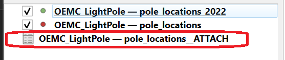
TableName=\pole_locations__ATTACH
FileGeoDatabaseFeatureLayer(C:\OriStar\xxxx\OriStarVisionMapSuite\MapGeoDatabase\OEMC_LightPole.gdb)
Source=Esri.FileGDBAPI
TargetSite=Void Init()
StackTrace= at Esri.FileGDB.RowCollectionEnumerator.Init()
at System.Linq.Enumerable.EnumerablePartition`1.MoveNext()
at GRU=.R0I=.XkI=(IEnumerable`1 returningColumnNames, Int32 startIndex, Int32 takeCount)
at ThinkGeo.Core.FileGeoDatabaseFeatureSource.GetAllFeaturesCore(IEnumerable`1 returningColumnNames, Int32 startIndex, Int32 takeCount)
at ThinkGeo.Core.FeatureSource.GetAllFeatures(IEnumerable`1 returningColumnNames, Int32 startIndex, Int32 takeCount)
at ThinkGeo.Core.FeatureSource.GetAllFeatures(ReturningColumnsType returningColumnTypes, Int32 startIndex, Int32 takeCount)
at OriStarFileDatabaseViewer.GeneralMethods.PopulateDatabaseCollectionGdb(String TheFile, String TheFilePath, String TheFileName, String TheFileTypeUpCase) in C:\OriStarMappingIncThinkGeoUI-V14.3.0Secondary\OriStarFileDatabaseViewer\TheGeneralMethods.cs:line 558
Message=An expected Field was not found or could not be retrieved properly.
Esri.FileGDB.FileGDBException: An expected Field was not found or could not be retrieved properly.
at Esri.FileGDB.RowCollectionEnumerator.Init()
at System.Linq.Enumerable.EnumerablePartition`1.MoveNext()
at GRU=.R0I=.XkI=(IEnumerable`1 returningColumnNames, Int32 startIndex, Int32 takeCount)
at ThinkGeo.Core.FileGeoDatabaseFeatureSource.GetAllFeaturesCore(IEnumerable`1 returningColumnNames, Int32 startIndex, Int32 takeCount)
at ThinkGeo.Core.FeatureSource.GetAllFeatures(IEnumerable`1 returningColumnNames, Int32 startIndex, Int32 takeCount)
at ThinkGeo.Core.FeatureSource.GetAllFeatures(ReturningColumnsType returningColumnTypes, Int32 startIndex, Int32 takeCount)
at OriStarFileDatabaseViewer.GeneralMethods.PopulateDatabaseCollectionGdb(String TheFile, String TheFilePath, String TheFileName, String TheFileTypeUpCase) in C:\OriStarMappingIncThinkGeoUI-V14.3.0Secondary\OriStarFileDatabaseViewer\TheGeneralMethods.cs:line 558
2025-03-13 15:25:03,204 ERROR OriStarFileDatabaseViewer - OriStarFileDatabaseViewer->DatabaseTableFeatureData.LoadDatabaseTableFeatureDataCollection:
Unable to GetAllFeatures
TableName=WATER
Source=ThinkGeo.FileGeoDatabase
TargetSite=ThinkGeo.Core.Feature b0I=(System.Collections.Generic.IEnumerable`1[System.String], Esri.FileGDB.Row)
StackTrace= at GRU=.R0I=.b0I=(IEnumerable`1 returningColumnNames, Row row)
at GRU=.R0I=.XkI=(IEnumerable`1 returningColumnNames, Int32 startIndex, Int32 takeCount)
at ThinkGeo.Core.FileGeoDatabaseFeatureSource.GetAllFeaturesCore(IEnumerable`1 returningColumnNames, Int32 startIndex, Int32 takeCount)
at ThinkGeo.Core.FeatureSource.GetAllFeatures(IEnumerable`1 returningColumnNames, Int32 startIndex, Int32 takeCount)
at ThinkGeo.Core.FeatureSource.GetAllFeatures(ReturningColumnsType returningColumnTypes, Int32 startIndex, Int32 takeCount)
at OriStarFileDatabaseViewer.DatabaseTableFeatureData.LoadDatabaseTableFeatureDataCollection(clsDatabaseTableItem& oDatabaseTableItem) in C:\OriStarMappingIncThinkGeoUI-V14.3.0Secondary\OriStarFileDatabaseViewer\cfDatabaseTableFeatureData.cs:line 321
Message=General function failure.
Esri.FileGDB.FileGDBException: General function failure.
at GRU=.R0I=.b0I=(IEnumerable`1 returningColumnNames, Row row)
at GRU=.R0I=.XkI=(IEnumerable`1 returningColumnNames, Int32 startIndex, Int32 takeCount)
at ThinkGeo.Core.FileGeoDatabaseFeatureSource.GetAllFeaturesCore(IEnumerable`1 returningColumnNames, Int32 startIndex, Int32 takeCount)
at ThinkGeo.Core.FeatureSource.GetAllFeatures(IEnumerable`1 returningColumnNames, Int32 startIndex, Int32 takeCount)
at ThinkGeo.Core.FeatureSource.GetAllFeatures(ReturningColumnsType returningColumnTypes, Int32 startIndex, Int32 takeCount)
at OriStarFileDatabaseViewer.DatabaseTableFeatureData.LoadDatabaseTableFeatureDataCollection(clsDatabaseTableItem& oDatabaseTableItem) in C:\OriStarMappingIncThinkGeoUI-V14.3.0Secondary\OriStarFileDatabaseViewer\cfDatabaseTableFeatureData.cs:line 321