Hi,
I have a problem with a WmsRasterLayer.
The name of the uri is https://services.sandre.eaufrance.fr/geo/zrpe?REQUEST=getCapabilities&service=WMS
You can see the result with this link http://www.sandre.eaufrance.fr/atlas/srv/fre/catalog.search#/map. (Osm is basemap and one layer Wms)
I’m trying to get this result in my project with thinkgeo but I have a system error.
Step 1 :
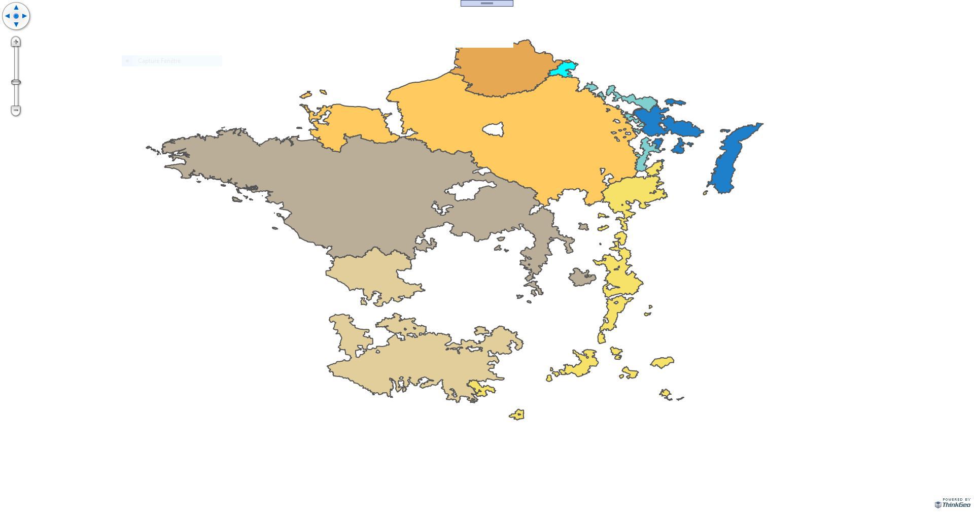
When I test the wms Sandre layer with this configuration, I visualize the map in my project (ie WmsLayerCrs4326.JPG)
MapWiuz.MapUnit = GeographyUnit.DecimalDegree;
MapWiuz.BackgroundOverlay.BackgroundBrush = new GeoSolidBrush(GeoColors.White);

var layerOverlay = new LayerOverlay();
var uri = new Uri("https://services.sandre.eaufrance.fr/geo/zrpe?REQUEST=getCapabilities&service=WMS");

var wmsRasterLayer = new WmsRasterLayer(uri);
wmsRasterLayer.ActiveLayerNames.Add("ZoneVuln_com_FXX");
wmsRasterLayer.Crs = "EPSG:4326";
wmsRasterLayer.OutputFormat = "image/png";
wmsRasterLayer.Parameters.Add("EXCEPTIONS", "xml");
wmsRasterLayer.Parameters.Add("TRANSPARENT", "TRUE");
wmsRasterLayer.ActiveStyleNames.Add("default");

layerOverlay.Layers.Add("ZoneVul", wmsRasterLayer);
MapWiuz.Overlays.Add(layerOverlay);
wmsRasterLayer.Open();
MapWiuz.CurrentExtent = wmsRasterLayer.GetBoundingBox();
MapWiuz.Refresh();
Step 2: I add the OSM background.
It is at this stage that I have concerns.
Osm is in projection 3857 with meters and Sandre is in 4326 and DecimalDegree
The configuration of my map is as follows:
  MapWiuz.MapUnit = GeographyUnit.Meter;
MapWiuz.BackgroundOverlay.BackgroundBrush = new GeoSolidBrush(GeoColors.White);

var layerOverlay = new LayerOverlay();
var uri = new Uri("https://services.sandre.eaufrance.fr/geo/zrpe?REQUEST=getCapabilities&service=WMS");

var wmsRasterLayer = new WmsRasterLayer(uri);
wmsRasterLayer.ActiveLayerNames.Add("ZoneVuln_com_FXX");
wmsRasterLayer.Crs = "EPSG:3857";
wmsRasterLayer.OutputFormat = "image/png";
wmsRasterLayer.Parameters.Add("EXCEPTIONS", "xml");
wmsRasterLayer.Parameters.Add("TRANSPARENT", "TRUE");
wmsRasterLayer.ActiveStyleNames.Add("default");

var osm = new OpenStreetMapLayer();

layerOverlay.Layers.Add("osm", osm);
layerOverlay.Layers.Add("ZoneVul", wmsRasterLayer);
MapWiuz.Overlays.Add(layerOverlay);

try
{
	wmsRasterLayer.Open();
	 MapWiuz.CurrentExtent = wmsRasterLayer.GetBoundingBox();
	MapWiuz.Refresh();
}
And I have a following error:
System.ArgumentNullException
HResult=0x80004003
Message=The parameter you supplied may be null.
Nom du paramètre : targetShape
Source=ThinkGeo.MapSuite.Wpf
Arborescence des appels de procédure :
à ThinkGeo.MapSuite.Wpf.Tile.DrawException(GeoCanvas geoCanvas, Exception exception)
à ThinkGeo.MapSuite.Wpf.Tile.Draw(GeoCanvas geoCanvas)
à ThinkGeo.MapSuite.Wpf.Tile.WlY=(Object status)
à System.Threading.QueueUserWorkItemCallback.WaitCallback_Context(Object state)
à System.Threading.ExecutionContext.RunInternal(ExecutionContext executionContext, ContextCallback callback, Object state, Boolean preserveSyncCtx)
à System.Threading.ExecutionContext.Run(ExecutionContext executionContext, ContextCallback callback, Object state, Boolean preserveSyncCtx)
à System.Threading.QueueUserWorkItemCallback.System.Threading.IThreadPoolWorkItem.ExecuteWorkItem()
à System.Threading.ThreadPoolWorkQueue.Dispatch()
à System.Threading._ThreadPoolWaitCallback.PerformWaitCallback()
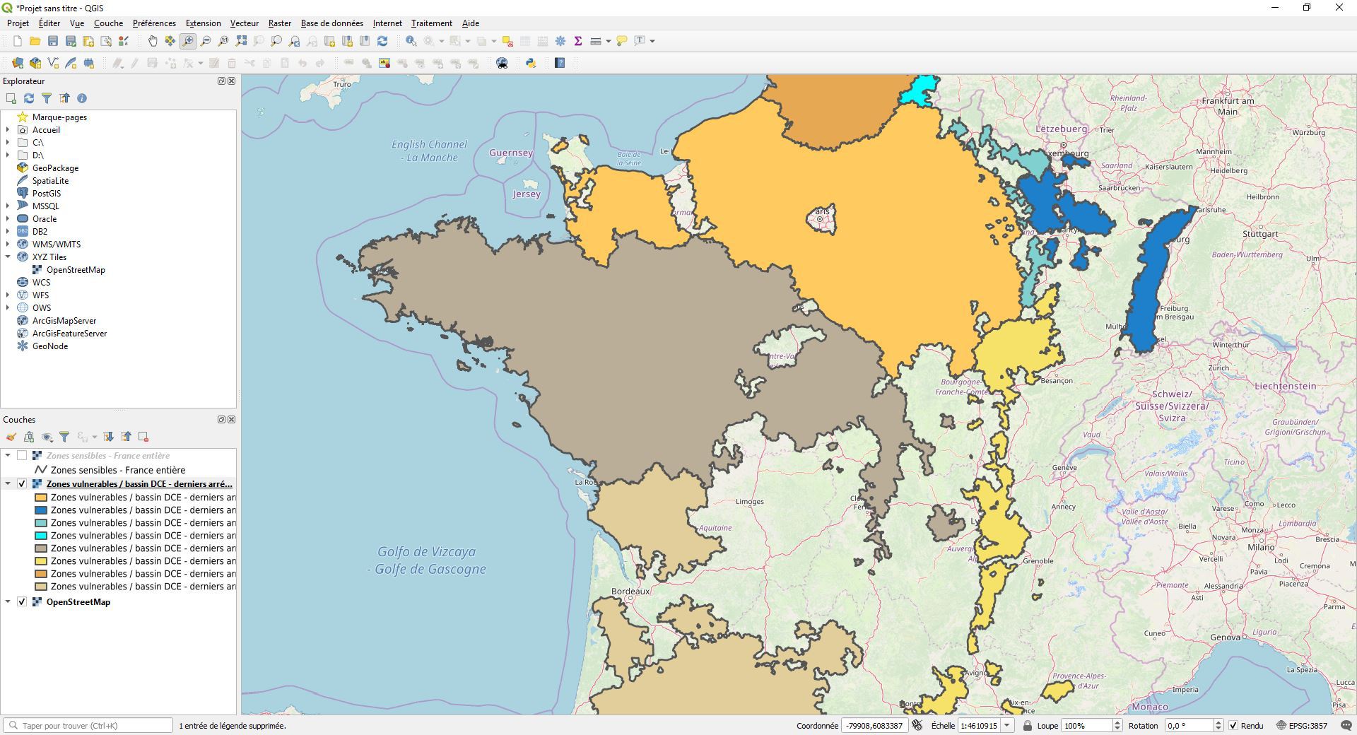
I’m doing the test with Qgis and I can have an Osm basemap and the Wms Sandre layer on top. (see screen shot WmsLayer_Osm_Qgis.JPG)
When I retrieve the Qgis query with Fiddler, the sent crs is 3857 and I get the following query.
GET /geo/zrpe?SERVICE=WMS&VERSION=1.3.0&REQUEST=GetMap&BBOX=-1755538.633639884414,4915264.179941010661,2092250.699577764841,7123412.148591595702&CRS=EPSG:3857&WIDTH=1577&HEIGHT=905&LAYERS=ZoneVuln_com&STYLES=&FORMAT=image/png&DPI=96&MAP_RESOLUTION=96&FORMAT_OPTIONS=dpi:96&TRANSPARENT= TRUE HTTP / 1.1
Are you able to reproduce my problem ?
Have you ever encountered this kind of problem?
Thanks a lot for your help.
Regards.
Steph.