Hi
Have made some screenshoots, the problem is in the bitmap layer.
To recreate problem, zoom intoworld map, insert some bitmaps and then zoom up/down. ( I insert about 400 points around world, most europe)
Some time the map only displays some, all and none.
Only zoom up/down add removes icons, panning at same zoom, dosen't make any difference.
OnLoad
winMap.Overlays.Add("WindFarmLayer", AddBitmapLayer("WindFarmLayer", VSU.Common.Ressources.Images.MapWindFarm, googleProjection));
MapWindFarm is an 16x16 png image.
private static LayerOverlay AddBitmapLayer(string name, VSU.Common.Ressources.Images image, Projection googleProjection)
{
var overlay = new LayerOverlay();
var layer = new InMemoryFeatureLayer();
layer.ZoomLevelSet.ZoomLevel01.DefaultPointStyle.PointType = PointType.Bitmap;
layer.ZoomLevelSet.ZoomLevel01.DefaultPointStyle.Image = new GeoImage (VSU.Common.Ressources.ImageMgr.Instance.GetImageAsStream(image));
layer.ZoomLevelSet.ZoomLevel01.ApplyUntilZoomLevel = ApplyUntilZoomLevel.Level20;
layer.FeatureSource.Projection = googleProjection;
overlay.Layers.Add(name, layer);
return overlay;
}
the layer is populated in an aysnc. callback.
private void m_vdcService_GetWindFarmItemsCompleted(object sender, VDCWindFarmItemEventArgs e)
{
if (InvokeRequired)
{
BeginInvoke(new EventHandler<vdcwindfarmitemeventargs></vdcwindfarmitemeventargs>(m_vdcService_GetWindFarmItemsCompleted), new object[] { sender, e });
}
else
{
btnShowWindFarms.Enabled = true;
progressControl.Visible = false;
progressControl.Stop();
if (e.Items.Count > 0)
{
winMap.Overlays["WindFarmLayer"].Lock.EnterWriteLock();
try
{
InMemoryFeatureLayer pointLayer = (InMemoryFeatureLayer)winMap.FindFeatureLayer("WindFarmLayer");
foreach (WindFarmItem item in e.Items)
{
Feature feature = new Feature(item.Longitude, item.Latitude, item.GetHashCode().ToString());
pointLayer.InternalFeatures.Add(item.GetHashCode().ToString(), feature);
}
}
finally
{
winMap.Overlays["WindFarmLayer"].Lock.ExitWriteLock();
}
winMap.Refresh();
m_windFarmsLoaded = true;
}
else
{
btnShowWindFarms.CheckState = CheckState.Unchecked;
}
}
}
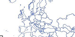
Pictures are at different zoom levels.
europe empty :(
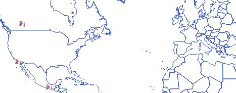
Total blackout